A cold wave isn’t just a Tuesday in January when you forget your scarf. It is an episode of intense cold. This stuff lasts for several days. It hits either an entire country or a specific region. But here is the thing. Not every cold period qualifies as a cold wave.
The term has strict criteria.
We are talking about specific temperature thresholds. We are talking about geographic extent. We are talking about duration. If you have one freezing night, that is weather. A sustained, widespread plunge that meets defined standards? That is a cold wave.
Defining the Thresholds
Why do we need these definitions? Because “cold” is relative.
In the Arctic, -10°C might be a warm day. In Florida, it is a disaster. Meteorologists need a baseline. They look at long-term averages for a specific region. A cold wave is triggered when temperatures drop significantly below those normal averages.
It’s not just about how low the thermometer reads. It’s about how far it deviates from the norm. And how long it stays there.
Why the Distinction Matters
Getting this right isn’t just academic. It affects how we respond.
If a region prepares for a cold wave, they are ready for infrastructure strain. Power grids can fail. Pipes can burst. Agriculture takes a hit. If we label every cold snap a “wave,” we dilute the warning. People stop listening.
The precise definition forces authorities to issue targeted alerts. It helps emergency services allocate resources. It tells the public to stock up. It separates a manageable chill from a potentially dangerous event.
The Three Pillars
To be officially classified, an event usually needs to check three boxes:
- Temperature: Must fall below a set percentile or absolute threshold for the area.
- Duration: Must persist for multiple days (usually 48 hours or more).
- Spatial Extent: Must cover a significant geographic area, not just a single town.
Without all three, it’s just a cold spell.
Real-World Impact
When these conditions align, the consequences are tangible.
- Health: Hypothermia and frostbite risks spike. Elderly populations are particularly vulnerable.
- Energy: Demand for heating surges. Blackouts become more likely if supply chains are stressed.
- Transport: Ice on roads and rails disrupts logistics. Flight cancellations mount.
This is not theoretical. These events rewrite daily life.
How Climate Change Fits In
Does a warming planet affect cold waves?
Counterintuitively, yes.
As the Arctic warms faster than the rest of the globe, the temperature gradient between the pole and the equator weakens. This can destabilize the jet stream. A wobbly jet stream allows cold air from the polar regions to dip southward more frequently.
It doesn’t mean every winter will be colder. But it does mean that when cold air does come, it can get stuck. Stuck air leads to prolonged cold events. Longer duration. Greater impact.
So the next time you shiver through a week of below-zero temps, remember: it’s not just cold. It’s a system. A rare, dangerous intersection of physics and geography.
And we

Why rare cold snaps in France still grab headlines
Most people assume winter is getting warmer. They are right, on average. But when the thermometer really drops, it feels apocalyptic. That is because these events are no longer routine.
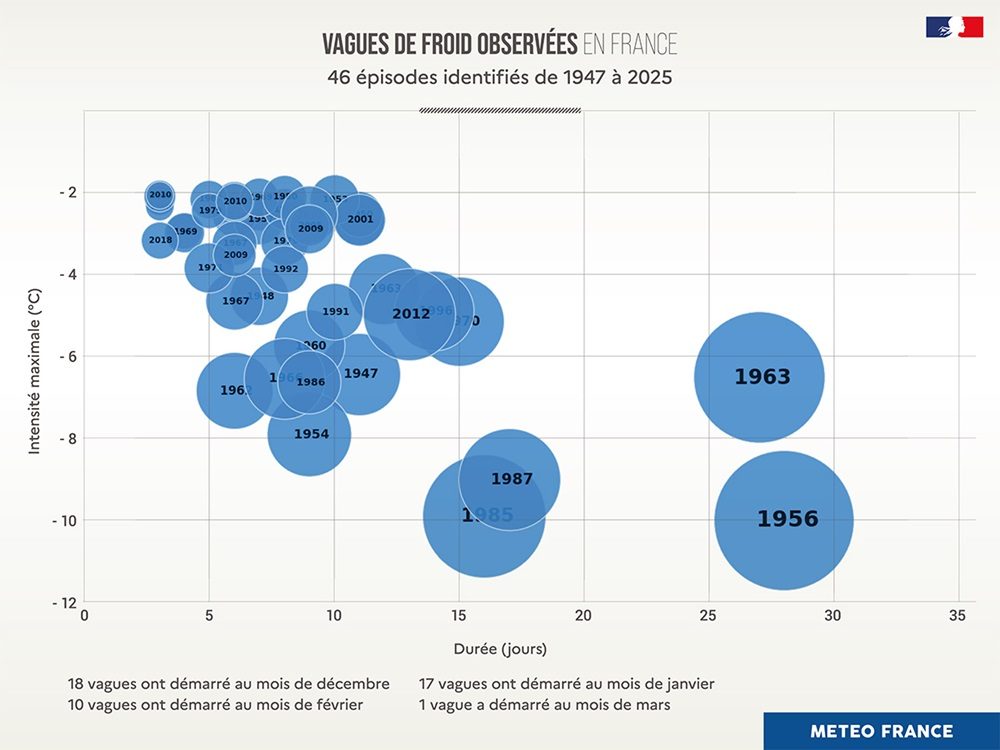
From 1947 to 2025, France has experienced exactly 46 cold waves that met Météo France’s strict criteria. Ten of those occurred in the 21st century alone. The frequency is dropping, but the intensity when they do happen remains terrifying.
The recent chill: 2018 and 2012
The last time France felt a true cold snap was February 2018. It was short. Three days. February 26th to 28th. Not intense by historic standards, but it still pushed temperatures down to -10°C or -15°C in the northeast. It felt late in the season, a final, weak gasp of winter.
Before that, look at February 2012. This was not a whimper. It was a roar. The cold lasted nearly two weeks. From the 1st to the 13th, temperatures plunged between -10°C and -18°C across many regions, creeping even into the countryside of the Paris basin. It ranks as the fifth most intense cold wave since records began. The most significant since 1987.
The record breakers: 1996, 1987, and 1985
History books are colder. Much colder.
The period from December 23, 1996, to January 17, 1997 broke the three-week barrier. The northern half of France was frozen solid. Temperatures hovered between -10°C and -15°C. Locally, they dipped below -20°C. Paris suffered through its coldest January afternoon in 150 years, hitting -8°C, according to meteorologist Guillaume Séchet.
Then there is January 1987. This event set records that still stand. A “Moscow-Paris” airflow dragged glacial air directly into the country. For sixteen days, from the 8th to the 24th, Paris saw -12°C. Alsace endured -22°C. Those numbers have not been beaten since.
But cold is not just about numbers. It is about bodies.
January 1985 remains one of the deadliest events of the century. At least 9,000 people died. The cold was brutal. Reims saw -20°C. Haute-Saône hit -24°C. The Jura mountains plunged to -40°C. The footage from France 3 news at the time showed a nation grappling with polar conditions in the Nord-Pas-de-Calais region.
Historical extremes: 1979, 1963, and 1956
Go back further. January 1979 hit twice. The first wave ran from the 1st to the 9th. The second from the 14th to the 19th. Cold air reached the southwest and southeast, with the center and east seeing -10°C to -15°C generally.
The winter of 1962-1963 is considered by Météo France as the most intense of the 20th century. It wasn’t one wave. It was four, stretching from November to March. Vichy recorded -26°C. This was an extreme winter for the entire northern hemisphere, but France bore the brunt.
And then there is February 1956. It is often cited as the coldest month since 1900. Russian air hit France with brutal speed. The northeast lost 20°C in a single day, between January 31st and February 1st. The cold lasted three weeks. Thousands died. On February 2, 1956, France recorded its coldest single day ever. The national average temperature hit -10°C. Locally, it reached -20°C to -32°C.
Before the official records
If you look before 1947, the numbers get speculative. They are not “official” Météo France data. But they are real enough.
December 1879 is legendary. Paris froze. Reports suggest temperatures hit -30°C in the Île-de-France region, driven by a Russian airflow. Paris itself saw -24°C. The area between the Vosges and the Jura mountains dropped to -30°C or -37°C. These are pre-automated records, but the destruction was tangible.
We track these events not just for the science. We track them because when the grid fails, when the pipes burst, when the death toll rises, the abstraction of “global warming” vanishes. The cold is physical. It is immediate. It does not care about averages.